CNES projects library
C
I
M
P
S
U
Saral/Altika
Launched on 25 February 2013, the SARAL/AltiKa satellite is a joint French-Indian project focusing on environmental observation and monitoring. The satellite bus, which was developed by the Indian space agency, carries two independent instruments—Argos-3 and AltiKa. Argos-3 is the third-generation receiver of the Argos system, able to locate and collect of environmental data from any ‘platform’ equipped with an Argos transmitter, from drifting buoys to turtles or birds.
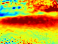
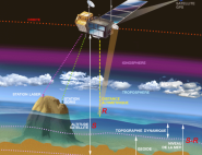
AltiKa is a ground-breaking payload that incorporates an altimeter, a radiometer and a DORIS positioning instrument. It measures ocean surface topography using a very high electromagnetic wave frequency—the Ka band (around 35.75 GHz instead of the previous 13.6 GHz). Developed for CNES by Thales Alenia Space, the AltiKa altimeter provides improved ground resolution, giving a clearer picture of coastlines and continental rivers and lakes. It also penetrates less deeply into snow and ice, thereby enabling collection of information about their surface levels. So, in addition to contributing to mesoscale (50 to 500 km) ocean current observations that are essential to our understanding of ocean dynamics and their impact on the climate, AltiKa data are also widely used by glaciologists and hydrologists.
Placed in the same 800-km polar orbit as the Envisat satellite, SARAL/AltiKa is able to acquire long time-series of data required for studying climate change. AltiKa data are also used in operational oceanography and on a daily basis by the Copernicus Marine Environment and Monitoring Service (CMEMS) and by the French and European national weather services.
Mission's news feed
-

El Niño: satellites see red
The wild child of the Pacific is shaping up to be a monster this winter, comparable to the 1997-1998 episode and possibly even worse. The story in pictures.
December 1, 2015
-
SARAL satellite in orbit
The Indian SARAL satellite was placed into orbit Monday 25 February from the Satish Dhawan Space Centre in southern India. The satellite is carrying AltiKa, a new-generation radar...
February 25, 2013
-
SARAL/AltiKa to enhance understanding of Earth’s climate
The French-Indian SARAL/AltiKa altimetry mission is scheduled to launch 25 February from the Satish Dhawan Space Centre in southern India. Its goal is to enable closer monitoring...
September 17, 2012